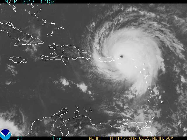
On August 30, 2017, just as Hurricane Harvey was winding down in Texas, tropical storm Irma formed near the Cape Verde Islands located off the northwest coast of Africa and began moving west-northwest. According to the U.S. National Hurricane Center, the largest and most powerful hurricanes, such as Ivan (2004), Isabel (2003), Hugo (1989), and Allen (1980), form in that region of the Atlantic Ocean. By September 1, Irma had become a Category 3 storm on the Saffir-Simpson Hurricane Wind Scale, with wind speeds of 185 kilometers per hour (115 miles per hour). It strengthened to a Category 5 storm on September 5, with maximum sustained winds of 298 km/h (185 mi/h). Category 5 storms have wind speeds of 252 km/h or higher (157 mi/h or higher) and are the most destructive type of hurricane to property and vegetation. See also: Atlantic Ocean; Cyclone; Extreme weather events; Hurricane; Hurricane Harvey (Atlantic, 2017); Tropical meteorology

On September 6, Irma slammed into the northern Leeward Islands as a Category 5 storm. It passed directly over the islands of Barbuda and Saint Martin, inflicting catastrophic damage and leaving their populations largely homeless and without power or telecommunications, before moving on to the Virgin Islands, which also suffered severe damage. Puerto Rico, the Dominican Republic, and Haiti sustained lesser damage, as the storm passed to their north. See also: West Indies
Warm oceans and low wind shear are two key ingredients that fuel and sustain hurricanes. As Irma approached Cuba on September 8, it passed over waters that were warmer than 30 degrees Celsius (86 degrees Fahrenheit)—warm enough to sustain it as a Category 4 to 5 storm. On September 9, Irma made landfall on northern Cuba as a Category 5 storm and weakened to a Category 4 storm while battering the Florida Keys as it headed toward mainland Florida. After making landfall on the mainland United States on September 10 with maximum sustained winds of 215 km/h (130 mi/h), Irma began losing strength as it headed up the west coast of Florida. By 8:00 a.m. EDT on September 11, Irma had weakened to a tropical storm with 112 km/h (70 mi/h) winds, according to the National Hurricane Center, and was headed north-northwest at 29 km/h (18 mi/h). See also: Ocean warming
In terms of wind speeds, Hurricane Allen (1980) remains the strongest-ever Atlantic storm, with maximum sustained winds of 310 km/h (190 mi/h). However, no hurricane worldwide has remained a Category 5 storm for as long as Irma did for three consecutive days. In terms of barometric pressure (lower is stronger), Irma ranks below the top 10 among Atlantic Hurricanes at 914 millibars (27 inches Hg). Another measure of a hurricane’s fury is the temperature of cloud tops—the lower the temperature, the greater the potential for heavy rainfall. On September 7, satellite measurements recorded very low cloud-top temperatures of −83.1 degrees Celsius (−117.7 degrees Fahrenheit). See also: Air pressure; Multispectral satellite observations of severe storms


