The field of gravitational attraction of the Earth. Since, at the Earth's surface, the small centrifugal force due to the Earth's rotation is inseparably superimposed on the attraction, the gravity field is usually understood to include also the effect of the centrifugal force.
Concepts
The gravitational potential V at a point P is the potential energy, due to the Earth's gravitational attraction, of a unit mass situated at P. In other words, V is equal to the work done if a unit mass is brought from infinity to the point P under the influence of the Earth's gravitational field. A mathematical expression is obtained by integrating over the Earth the formula for the potential of a point mass, but this expression is almost useless for practical application. For the potential outside the Earth, an expansion into an infinite series (of spherical harmonics, discussed later in this article) is useful; the principal term of this series is GM/r. This term, in which G is the Newtonian gravitational constant (6.67 × 10⁻⁸ m3 kg−1 s−2), M is the total mass of the Earth, and r is the distance of P from the Earth's center of mass, represents formally the attraction of a spherically symmetric Earth; the consideration of this term only is not, in general, sufficient. The gravitational force F on a unit mass is the gradient vector of V, F = grad V; that is, the components of F are (∂V/∂x, ∂V/∂y, ∂V/∂z).
Gravitation and gravity
The resultant of gravitation (pure attraction) and centrifugal force is called gravity. Gravity is the force that acts on the body at rest with respect to the Earth since the effects of attraction and of centrifugal force cannot be separated because of the equivalence of gravitational and inertial mass; thus gravity determines the weight of a body. The gravity potential W is the sum of the gravitational potential V and the potential of centrifugal force, which is given by a simple analytical expression and may be considered as known.
A body moving with respect to the Earth is also affected by the Coriolis force. Like centrifugal force, the Coriolis force is an inertial force due to the Earth's rotation, but unlike centrifugal force, it does not possess a potential and hence cannot be easily incorporated into the gravity field. Therefore Coriolis force is not considered in the context of terrestrial gravitation. This is perfectly adequate since this force is zero for bodies at rest with respect to the Earth, and almost all measuring systems are at rest. See also: Coriolis acceleration; Gravitation
Gravity vector
The gravity vector g represents the force of gravity on a unit mass. It is the gradient vector of the gravity potential, g = grad W. The magnitude of the gravity vector is the intensity of gravity, or briefly, gravity g. The dimension of g is force per unit mass, or acceleration. The SI unit is m · s−2. The cgs unit gal (1 gal = 1 cm · s−2), named after Galileo, is still frequently used, especially the milligal (1 mgal = 10−3 gal = 10−5 m · s−2). Gravity g on the Earth's surface varies from about 978 gals at the Equator to about 983 gals at the poles. The direction of the gravity vector defines the vertical, or plumb line.
Geoid
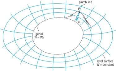
The surfaces of constant gravity potential, W = const, are called equipotential surfaces or level surfaces. The surface of a quiet lake is part of a level surface. So is the surface of the oceans, after some obvious idealization; the whole level surface so defined is called the geoid. After C. F. Gauss, the geoid is considered as the mathematical surface of the Earth, as opposed to the visible topographical surface. The plumb lines intersect the level surfaces orthogonally (Fig. 1); they are not quite straight but very slightly curved.
Measurement
The quantity that is measured most commonly is the gravity g. The determination of g as such is called an absolute gravity measurement. Usually only relative gravity measurements are performed, determining the difference between, or the quotient of, the gravity values at two different points. The direction of the gravity vector, which gives the plumb line in space, is measured by astronomical methods. Differences in the gravity potential W are obtained by geodetic leveling. Finally, certain derivatives of g and similar quantities are measured by instruments such as the torsion balance.
Satellite methods have enormously improved knowledge of the gravity field. In the future, new satellite technologies will advance gravity-related measurements, to be studied along with classical theoretical measurements, which will fully retain their importance. See also: Gravity
Classical gravity measurements
Absolute gravity measurements are now exclusively performed by falling–body instruments, which use the fact that the free fall of a test object is proportional to gravity g: if a body, originally at rest, is dropped in vacuum, the vertical distance s covered during time t is represented by Eq. (1), which gives Eq. (2).
Since s and t can be very accurately measured, gravity g is obtained with a relative accuracy of 10−8 to 10−9. Both stationary and movable instruments are used routinely.
The former use of pendulum apparatuses for measuring absolute g gave only a relative accuracy of 10−6 and is now completely obsolete.
Relative gravity measurements are performed by spring gravimeters, which are based on Hooke's law: the extension s of the elastic spring is proportional to the force of gravity, so that the difference of gravity g between two points P1 and P2 is given by Eq. (3),
where k is a factor of proportionality. The same principle is used in accelerometers. The accuracy is consistent with that of modern absolute gravity measurements. See also: Accelerometer; Gravity meter
Since relative gravity measurements are much simpler, absolute determinations of gravity are performed only at relatively few points on the Earth's surface. At other points, gravity is determined relative to these absolute stations. Relative measurements of gravity are made by pendulums or gravimeters.
Basically, an instrument that measures gravity (a gravity sensor) is nothing but a special form of accelerometer. The principle of the spring balance is also utilized for accelerometers, and inversely vibrating-string accelerometers have been proposed as gravity sensors since the frequency of a loaded vibrating string is a function of g. Accelerometers have been especially proposed for use in gradiometers, as discussed in the section below on gravity gradients.
Direction of gravity vector
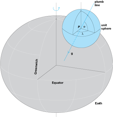
This direction, the plumb line, is defined by two angles; ϕ, geographical latitude, and λ, geographical longitude (Fig. 2). These angles are determined by astronomical methods to an accuracy of 0.1 second of arc or better. If g, ϕ, and λ are known, then the gravity vector g is completely determined.
Potential differences
Differences in the potential W can also be measured. If dn is the distance between two neighboring level surfaces of potential difference dW, then dW = −g dn, so that Eq. (4) holds.
The geodetic operation of leveling (spirit leveling or differential leveling) determines dn. The leveling increments dn are multiplied by gravity g and summed along the leveling line that connects points A and B. In this way the difference of potential W between A and B is determined.
Gravity gradients
The gradient of gravity along a certain direction s, ∂g/∂s, is the component of the vector grad g along this direction. Instruments measuring gravity gradients are called gradiometers.
Horizontal gradients (gradients along any horizontal direction) are obtained by means of the torsion balance invented by R. Eötvös about 1900. This instrument consists essentially of a vertically suspended torsion wire carrying a light horizontal beam at which two equal masses are suspended at different heights. The torsion balance gives horizontal gradients of g and, in addition, certain characteristics of the curvature of equipotential surfaces.
The practical application of the torsion balance has suffered from the competition of modern gravimeters, but the interest in gradiometers is being revived because they can be used for gravitational measurements aboard an artificial satellite (a gravimeter would in this case constantly indicate g = 0!).
A general gradiometer may be viewed as a combination of two gravity sensors separated by a small distance; the difference in their readings, divided by the distance, gives the gravity gradient. The use of vibrating-string sensors, mentioned above, has been proposed for this purpose. The full power of this technique will be achieved by satellite gradiometry.
Gravitational Field
The gravitational field of a reference ellipsoid of revolution which closely approximates the real Earth is called the normal field. The difference between the real field and the normal field is called the anomalous field.
Normal field
Since the Earth is very nearly an ellipsoid, the gravity field of a suitable ellipsoid of revolution is a good approximation to the gravity field of the Earth and can thus be considered as a normal terrestrial gravity field. The normal gravity potential is denoted by U. An ellipsoid of revolution—the reference ellipsoid—that is close to the geoid is defined to be an equipotential surface of this normal field, where U = U0 = constant.
Normal gravity
Gravity on such a “level ellipsoid” is called normal gravity γ; it is given by the gravity formula, Eq. (5),
where γe is normal gravity at the equator, ϕ is geographical latitude, and ∊ is a very small constant (for numerical values see below).
The other constant, β, is related to the geometric flattening of the terrestrial ellipsoid, f = (a − b)/a (where a = semimajor axis and b = semiminor axis) by A. C. Clairaut's formula, Eq. (6),
where m = centrifugal force at Equator/gravity at Equator, in which terms of the second order in f are neglected. This remarkable relation permits the determination of the Earth's flattening f from gravity measurements.
The level ellipsoid and its gravity field are defined by four constants, for example, the set (a, GM, J2, ω). Here a and GM have been introduced before; J2 is the dynamical form factor or dynamical ellipticity of the Earth, defined as J2 = (C − A)/Ma2, where C and A are the Earth's principal moments of inertia; and ω is the Earth's angular spin velocity.
The constants f, β, and γe are related to these constants, to the first order in f, by the formulas (7), (8), and (9).
The set of values given below defines the Geodetic Reference System 1980 adopted by the International Union of Geodesy and Geophysics.
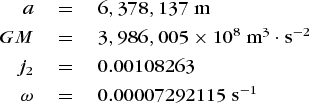
The corresponding flattening is f = 1/298.257, and the gravity formula becomes Eq. (10).
External and internal field
Gravity above the ellipsoid decreases according to formula (11),
where γh is gravity at elevation h and latitude ϕ, and γ is the gravity at the same latitude on the surface of the ellipsoid; γh and γ are measured in gals, and h is measured in kilometers.
As for the internal field, the internal level surfaces are approximately ellipsoids that become more and more spherical with increasing depth. The theory of the internal field is governed by a differential equation published by Clairaut in 1743. This equation relates the flattening of the level surfaces to the density under the assumption of hydrostatic equilibrium. The solution of this equation offers a possibility of computing the flattening of the Earth from the constant of astronomical precession, which is quite accurately known. Values for f obtained in this way and values obtained more directly from the analysis of satellite orbits, from J2 [see Eq. (10)], show discrepancies which have yet to be completely explained.
Anomalies of the gravitational field
The normal ellipsoidal field incorporates the main part of the Earth's gravitational field. The difference between the real field and the normal field is called the anomalous field. The anomalous potential T is the difference between the actual gravity potential W and the normal gravity potential U. (The circumstance that the symbol T has been previously used to denote the period of oscillation of a pendulum will cause no confusion.)
Other quantities of the anomalous field are the gravity anomaly and the deflection of the plumb line. Both are more readily accessible to observation than the anomalous potential T, and they may be used to determine T.
Gravity anomalies
The gravity anomaly Δg is defined as the difference between gravity at sea level, g, and normal gravity at the reference ellipsoid, γ: Δg = g − γ. Since measurements are not generally made at sea level, the measured gravity value must be reduced from the Earth's surface to sea level, that is, to the geoid. Depending on the way in which this is achieved, different types of gravity anomalies are obtained.
This reduction may be done without considering the masses below the observation station; that is, g is reduced as if these masses did not exist and the station were “in free air.” This is the free-air reduction. The amount of this reduction, to be added to the measured gravity, is by formula (14) approximately 0.309h mgals, where h is the elevation in meters.
In the process of gravity reduction, the masses above the geoid may also be removed computationally. This is the Bouguer reduction. The amount to be added to measured gravity is now 0.197h, the units being the same as before; this figure is based on a rock density of 2.67 g/cm3.
Instead of completely removing the masses above the geoid, they may be shifted computationally into its interior in such a way as to get a level homogeneous crust according to some theory of isostasy (see later section of this article). This is an isostatic reduction. There are also a number of other gravity reductions.
Deflections of plumb line
The deflection of the plumb line, or deflection of the vertical, is the deviation of the actual plumb line from the normal to the reference ellipsoid. It is characterized by two components, the component ξ in a northern direction and the component η in an eastern direction. If ϕn and λn are the normal (ellipsoidal) coordinates, as opposed to their actual counterparts ϕ and λ, then ξ and η are given by Eqs. (12) and (13).
Astronomical observations give ϕ and λ, whereas ϕn and λn may be obtained from geodetic work such as triangulation. The ξ and η so determined are called astrogeodetic deflections of the vertical.
Anomalous potential and the geoid
The height of the geoid above the reference ellipsoid, the geoidal height N, is intimately related to the anomalous potential T by Bruns's formula, T = γN, where γ is normal gravity. Therefore, the determination of T is equivalent to the determination of the geoid.
A relative determination can be made by the astrogeodetic method. Differences TB − TA or NB − NA are obtained by integrating astrogeodetic deflections of the vertical along a line connecting the points A and B. By this method it is possible to determine the geoid in a limited region from data (plumb-line deflections) in this region only. The astrogeodetic method furnishes very detailed and accurate geoidal maps (or maps of the potential T) in areas where good astrogeodetic data are available. However, since this method is only relative, the position of the geoid so obtained is determined only apart from an unknown shift with respect to the Earth's center of mass. The use of the astrogeodetic method is restricted to land areas because the necessary data cannot yet be obtained at sea.
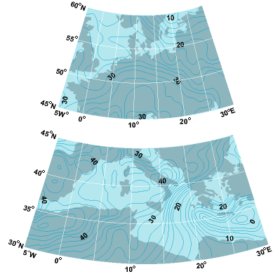
An absolute determination of the anomalous potential or the geoidal height can be achieved from gravity anomalies Δg. This is done by an integral formula due to Stokes (1849). Stokes' formula determines the geoid absolutely; that is, the geoidal heights so obtained refer to an ellipsoid whose center coincides with the Earth's center of mass. It requires the gravity anomalies to be given all over the Earth; this is practicable because gravity can be measured at sea as well as on land areas. Large regions, especially the oceans, have not been satisfactorily surveyed gravimetrically. This brings about certain restrictions on the practical applicability of the gravimetric method; nevertheless it has given important results. Figure 3 shows part of the “Columbus Geoid,” a historical landmark computed at Ohio State University.
Harmonic analysis
A periodic function can be expanded into a Fourier series; this is called harmonic analysis. Harmonic analysis may be generalized to functions of more than one variable, such as T or Δg. Instead of Fourier series there is, in this particular case, series of spherical harmonics; such series are applied also in other geosciences, such as geomagnetism.
A series of spherical harmonics is infinite. In practice, there is usually a restriction to series truncated after terms of lower degree. Higher degree terms cannot be determined properly and must be neglected. In this way the general broad features of the expanded function are retained, although fine details are lost.
The spherical-harmonic expansion of T is readily obtained if such an expansion of Δg is available. The practical use of this method is again impaired by the lack of gravity data on parts of the Earth's surface, but this drawback can be largely compensated by a combination of terrestrial and satellite data.
The motion of an artificial satellite in the Earth's gravitational field is most strongly affected by the harmonics of lower degree. Therefore satellite observation gives values of the lower degree spherical harmonics of the potential, which provide a good qualitative picture of the general behavior of the terrestrial gravity field and, in particular, of the large features of the geoid (Fig. 4). See also: Spherical harmonics
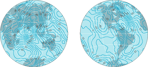
The practical use of spherical-harmonic expansions for representing the Earth's gravity field is usually expressed in terms of the geoid, and is of basic importance. The expansions are usually obtained by a combination of satellite and gravity data. Satellite orbital data give realistic expansions up to degree of about N = 30, with a geoidal accuracy of about ±5 m (16 ft) and a resolution which can be estimated as follows. One degree of arc corresponds to roughly 100 km (61 mi) of distance of the Earth's surface. A spherical-harmonic expansion to degree of N = 30, Eq. (14)
gives about 180°/30 = 6° = 600 km (37 mi) which, together with a rms error of about δN = ±5 m (16 ft) is not very satisfactory. This was the state of the art at the beginning of the satellite era, around 1965.
Nowadays, earth gravity models (EGM) combine satellite data with terrestrial gravity and are computed to a spherical-harmonic degree of N = 360. This improves the resolution by Eq. (14) to 0.5° = 50 km (30 mi) [theoretically], the accuracy being about 1 m (3.3 ft) or better. Current models even use N = 720 with about the same real accuracy since the same data are used.
Even N = 1000 is being envisaged, but without significantly new kinds of measurements it is difficult to really improve the situation. Such new techniques are satellite-to-satellite tracking (SST) and satellite gravity gradiometry (SGG), combined with the Global Positioning System (GPS). These techniques will be outlined below (satellite altimetry has already been taken into account in the N = 360 and 720 models).
Satellite altimetry
A direct determination of the oceanic geoid has become possible by measuring the height of a satellite above sea level. This is done by observing the travel time of a radar or laser signal emitted by a satellite and reflected by the ocean surface. If the satellite orbit is known with respect to the reference ellipsoid, the geoidal height follows. A breakthrough in understanding the ocean geoid was achieved by the altimetry satellites GEOS 3, 1975–1977, and Seasat, 1978.
Satellite-to-satellite tracking
The distance between two satellites changes with location in space due to the irregularities of the gravity field. If continuously and accurately monitored, information of the irregular field may be obtained. Roughly, N = 100 could be expected. Implementation will come soon after the year 2000.
Gravity gradiometry
This is an application of the principle of terrestrial gradiometry mentioned above to a gradiometer built into a satellite. Achievable resolutions are higher than with satellite-to-satellite tracking: N = 250 is being considered feasible. In combination with other satellite and terrestrial techniques, realistic N = 720–1000 models with accuracies on the order of a few centimeters appear possible. Practical application is to come slightly after satellite-to-satellite tracking.
Global Positioning System
GPS and its Russian counterpart, GLONASS, are purely geometrical and therefore (almost) independent of the gravity field. By furnishing precise positions, they make possible a separation of gravitational and geometric effects. In particular, GPS gives inertial accelerations (second derivatives of position) and thus separates them from the truly gravitational forces. This permits putting gravimeters and gradiometers into an airplane whose position is monitored by GPS. At least, airborne gravimetry is already a practically applied reality.
Each of these methods—astrogeodetic, GPS, gravimetric, and the different satellite techniques—has its specific merits and shortcomings. In many respects, they complement each other. By suitable combinations of these data, a very precise gravity field, formulated in terms of a “centimeter-geoid,” may become a reality in the near future.
Temporal variations
For most purposes, the Earth's gravitational field may be considered invariable in time. However, it is subject to extremely small periodic variations due to tidal effects. These are caused by the attraction of the Sun and Moon. The attraction acts directly by superimposing itself onto the Earth's gravitational attraction; and it acts also indirectly by slightly deforming the Earth and shifting the waters of the oceans, so that the attracting terrestrial masses themselves are modified.
The lunar effect on gravity attains a maximum of 0.20 mgal, and the solar effect, a maximum of 0.09 mgal; both are well within the measuring accuracy of modern gravimeters. The results of stationary gravimeters recording variations of gravity may be used to draw conclusions as to the elastic behavior of the Earth under the influence of tidal stresses. See also: Earth tides
Relations to Other Research
The determination of Earth's gravitational field depends on other studies, such as the astronomical determination of the plumb line, and has application in the search for mineral deposits and so on.
Geophysics and geology
The anomalies of the terrestrial gravitational field are caused by mass irregularities. These may be the visible irregularities of topography such as mountains; or they may be invisible subsurface density anomalies. This is the reason why it is possible to use gravity measurements for investigating the underground structure of the Earth's crust. Thus analysis of gravity is applied by geophysicists and geologists for studying general features of the crust, and by exploration geophysicists for searching for shallow density irregularities that might indicate the presence of mineral deposits.
Isostasy
If the mountains were simply superposed on an essentially homogeneous crust and if the ocean depressions were simply hollowed out from such a crust, the irregularities of the gravity field would be almost 10 times as large as they actually are. This indicates that the visible mass anomalies, such as mountains or ocean depressions, are to a large extent compensated: The crustal density underneath the mountains is smaller than normal, and underneath the oceans, greater than normal.
Theories of isostasy were developed by J. H. Pratt and by G. B. Airy, both about 1850. According to Pratt, the mountains have risen from the under-ground somewhat like a fermenting dough (Fig. 5). According to Airy, the mountains are floating on a fluid lava of higher density, somewhat like an iceberg on water, so that the higher the mountain the deeper it sinks (Fig. 6).
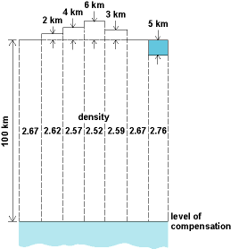
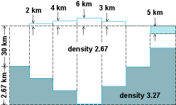
Pratt became aware of isostatic compensation through investigating astrogeodetic deflections of the vertical in the Himalayas. At one station he computed from the visible masses a deflection of 28 seconds of arc, whereas the observed value was only 5 seconds of arc.
Isostasy is also the reason for a conspicuous behavior of the Bouguer anomalies in mountain areas. Here they are systematically negative and increase in magnitude on the average about 100 mgals/1000 m of mean elevation.
If isostatic compensation were complete, then the isostatic gravity anomalies as defined above would be zero. In general, they are small and fluctuate smoothly around zero; this property makes them particularly well suited for interpolation and extrapolation to poorly observed areas in geodetic applications. Systematically nonzero isostatic anomalies indicate deviation from isostatic equilibrium. Therefore isostatic gravity anomalies, and also Bouguer anomalies, are used to investigate the degree and the mode of isostatic compensation. It appears that the Earth's crust is compensated isostatically to about 90%. The compensation seems in general to be of Airy type rather than Pratt type. See also: Earth
Exploration geophysics
Local mass anomalies at shallow depth, which might be related to mineral deposits, are discovered by a local very dense and accurate gravity survey by means of gravimeters. Bouguer anomalies are computed to eliminate as far as possible the effect of visible masses, and various filtering techniques are employed to isolate and localize disturbances. See also: Geophysical exploration
Geodesy
Geodetic instruments employ spirit levels and other devices to orient them with respect to the horizontal or, what amounts to the same thing, to the plumb line. Since the plumb line is defined by the gravitational field, it can be understood why this field enters essentially into almost all geodetic measurements, even into apparently purely geometric ones. In return, geodetic techniques are among the most efficient means for determining the gravitational field. The “mathematical figure of the Earth” for the purpose of geodesists, the geoid, is defined as a surface of constant potential W. “Heights above the sea level” are heights above the geoid; their determination is therefore a physical as well as a geometric problem. (Geodetic theories have been developed which employ only quantities referred to the Earth's topographical surface; but here the gravitational field enters in an even more complicated way.) Thus geodesy is essentially concerned with the Earth's gravitational field and its determination; the theory of the figure of the Earth is to a large extent equivalent to the theory of terrestrial gravitation. See also: Geodesy
Astronomy and satellite dynamics
Astronomical observations are indispensable for determining the plumb line, which defines the direction of the gravity vector. Parameters of the Earth's gravitational field such as equatorial gravity γe are used to express in kilometers the fundamental astronomical unit, the mean distance of Sun and Earth. The Earth's equatorial radius a, which gives the scale of the geoid, is also used as a basic astronomical constant. See also: Astronomical unit; Earth rotation and orbital motion
Terrestrial gravitation affects the motion of the Moon and of the artificial satellites. By observing these satellites, it is therefore possible to determine essential parameters of the gravitational field, such as the geocentric gravitational constant GM, which is the product of the Newtonian gravitational constant and the Earth's mass. The dynamical ellipticity J2 defined above, and other lower degree coefficients of the spherical-harmonic expansion of the gravitational potential, may also be determined in this way. GM and J2 are the coefficients of degrees zero and two of this expansion. See also: Satellite (spacecraft)


