Key Concepts
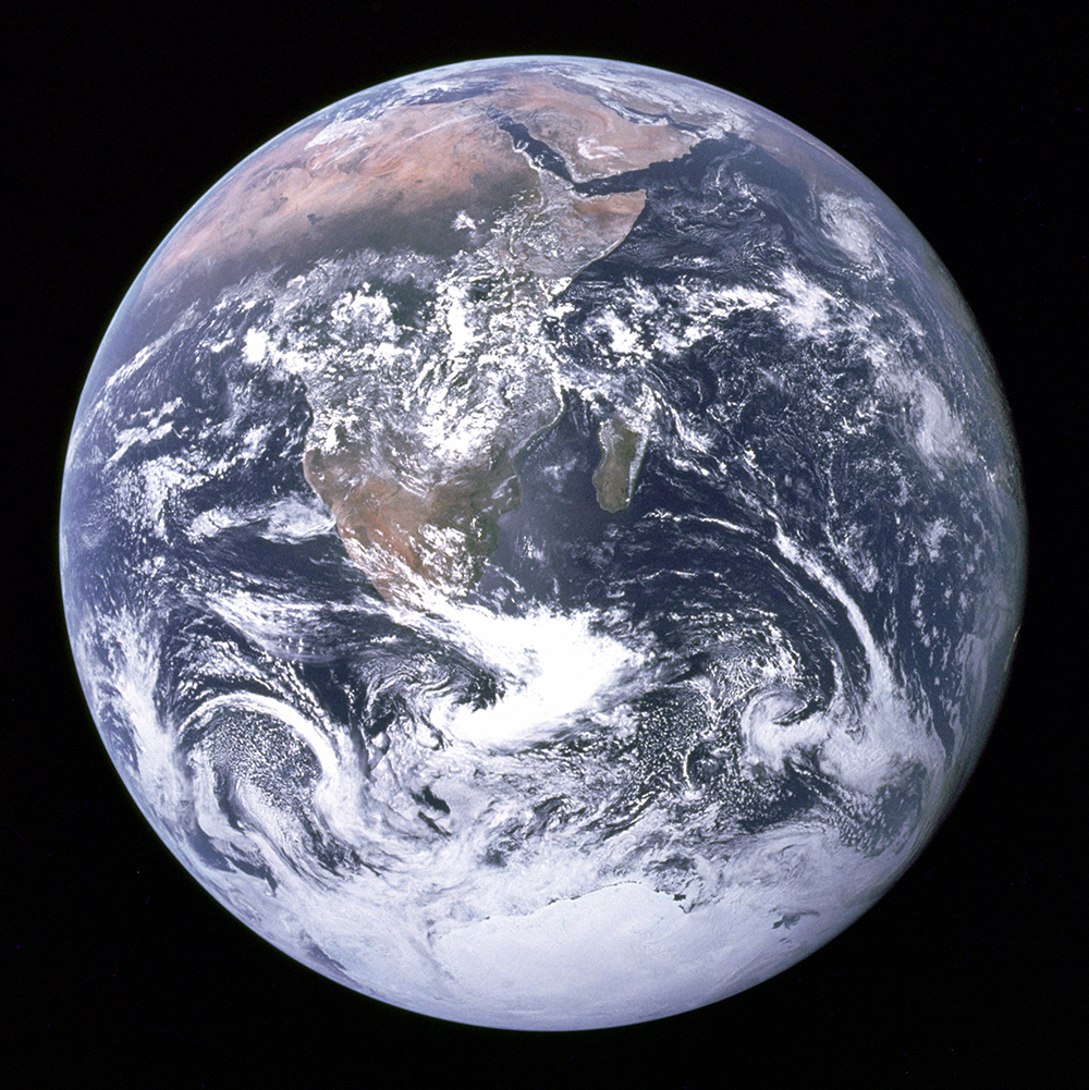
The third planet from the Sun and the largest of the four inner, or terrestrial, planets. The Sun is an average-sized, middle-aged star situated in the Milky Way Galaxy. So far as is known, Earth (Fig. 1) is unique in the solar system in having life. Whether life exists in the universe beyond the solar system is unknown. However, there are planets in orbit around many nearby stars, so of the possibility exists for Earth-like planets in the universe where life may yet be discovered. See also: Astrobiology; Biology; Exoplanet; Galaxy; Milky Way Galaxy; Planet; Solar system; Star; Sun; Universe
Earth has one natural satellite, the Moon. Otherwise, Earth's nearest neighbors in space are Venus, which is about 108 million km (67 million mi) from the Sun, and Mars, about 228 million km (141 million mi) from the Sun. Earth is about 150 million km (93 million mi) from the Sun. Distances between planets are so immense that it is difficult to comprehend them. To put the solar system into perspective, think of the Sun as a basketball. The planet closest to the Sun, Mercury, would be the size of a grain of sand slightly less than 1 mm in diameter and 12 m from the basketball. Venus, the second planet out, would be a granule 2.4 mm in diameter, 22 m away, and Earth would be a granule 2.5 mm in diameter, 30 m from the basketball. See also: Mars; Mercury (planet); Moon; Venus
Motions
A person standing on the surface of Earth undergoes a complex motion through space. The motion has two principal components: one arising from the orbital motion of Earth around the Sun and the other from the rotation of Earth around its axis.
Orbital motion
Earth completes an orbit around the Sun in 365 days, 5 h, 48 min, 46 s; the orbit defines the length of the year. The length of the day is determined by the period of Earth's rotation about its axis. The fact that the year is not a whole number of days has affected the development of the calendar. See also: Calendar
The orbit is close to circular but is actually elliptical with the Sun at one focus. Earth's closest approach to the Sun (perihelion), which happens about January 3, brings Earth to within 147 million km (91.5 million mi); Earth is at aphelion (farthest from the Sun) about July 4, when Earth is 152 million km (94.5 million mi) away. The average velocity of Earth in its orbit is 107,000 km/h (66,600 mi/h), or 29.6 km/s (18.5 mi/s). Because the orbit is elliptical, Earth's velocity varies systematically, being greatest at perihelion and least at aphelion. The changing velocity affects measurements of solar time. See also: Celestial mechanics; Orbital motion
Rotation
Earth rotates on its axis once each day. The axis of rotation is perpendicular to the Equator, and the Equator is inclined at about 23.5° to the plane of Earth's orbit around the Sun. Earth's north spin axis, or north geographic pole, points in the direction of the star Polaris, making it the North Star or polestar. One result of the tilt of the Equator relative to the orbital plane is that different parts of Earth receive differing amounts of sunlight through the year; this is the primary cause of seasons. See also: Equator; Polaris; Rotational motion
Earth's spin axis has not always pointed in the direction of Polaris. Earth is not a sphere; it bulges at the Equator so that the equatorial radius is 21 km (13 mi) greater than the polar radius. The gravitational attractions of the Sun and Moon on the equatorial bulge cause the spin axis to slowly trace out a cone in space—that is, as time passes, the north spin axis will no longer point toward Polaris. This slow conical motion of the spin axis is called precession, and a complete cycle requires 25,800 years. Superimposed on the precession is a much smaller fluctuation, called nutation, that results from the movement of the Sun twice a year, and the Moon twice a month, across the plane of the celestial equator. See also: Earth's gravity field; Precession of equinoxes
Earth's period of rotation, the day, is used to define the second, which is the basic unit of time. The length of the day varies irregularly owing to tidal friction, motions in Earth's core, and seasonal atmospheric circulation. For this reason, the second was previously defined as 1/86,400 of a mean solar day averaged over a year. To avoid the obvious problems in determining the length of the mean solar day, the second is now defined atomically. See also: Atomic clock; Day; Time
Earth's speed of rotation is a maximum in late July and early August, and a minimum in April; the difference in the length of the day is about 0.0012 s. Since about 1900, Earth's rotation has been slowing at a rate of about 1.7 s per year. In the geologic past, Earth's rotational period was much faster. Daily, monthly, tidal, and annual growth rings on fossil marine organisms reveal that about 350 million years ago (Middle Devonian Period) the year had 400–410 days, and 280 million years ago (Pennsylvanian Period) the year had 390 days. These observations are very close to the calculated values of the effect of tidal friction. The slowing of Earth's rotation is caused by tidal friction between the sea floor and the ocean water. The Moon is the main cause of tides, and the total rotation energy in the Earth-Moon system is conserved, so that the energy lost by Earth is gained by the Moon. This causes the Moon to move farther from Earth, and this in turn lengthens the period of the Moon's revolution. See also: Devonian; Earth rotation and orbital motion; Pennsylvanian; Tide
Satellites
The Moon is Earth's only natural satellite. The Moon's mass is 1/81.3 of Earth's, and its average distance from Earth is 383,403 km (238,247 mi). The center of mass of the Earth-Moon system is within Earth, about 4645 km (2886 mi) from Earth's center, and it is about this point that the Earth-Moon system revolves.
The Moon's period of revolution and rotation is 27 days, 7 h, 43 min, 11.5 s. The orbital plane of the Earth-Moon system is inclined to the orbital plan of the Earth-Sun system at an angle of 5°8′33′′. At times the Sun, Earth, and Moon are in a line, and an eclipse of the Sun or the Moon occurs. See also: Eclipse; Satellite (astronomy)
Size, shape, mass, and density
Earth is an oblate spheroid. The mean equatorial radius is 6378.139 km (3963.37 mi), and the polar radius is 6356.779 km (3950.10 mi), the difference being 21.360 km (13.27 mi).
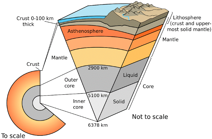
Earth's mass is 5.976 × 1024 kg, being the sum of 5.974 × 1024 kg for solid Earth, 1.4 × 10²¹ kg for the ocean, and 5.1 × 10¹⁸ kg for the atmosphere. Earth's average density is 5.518 g/cm3, which is just about double the density of the common rocks that form at Earth's surface, indicating that Earth's interior is denser than the surface. Seismic studies have confirmed that Earth is layered both compositionally and mechanically (Fig. 2). See also: Atmosphere; Density; Earth's interior; Oceanography; Seismology
Internal structure
The deepest compositional layer is the core, which is divided into a solid inner core and a liquid outer core. Both the inner and outer core have the same composition, believed to be nickel-iron plus a small amount of lighter elements such as sulfur and silicon. Electric currents moving in the molten metal outer core are believed to be the origin of Earth's magnetic field. Above the core is the mantle which, on the basis of density of rare rock samples brought up from deep in the mantle in kimberlite pipes, and other evidence, is believed to be composed of silicate minerals, and in particular olivine and pyroxene. A rock composed largely of olivine and pyroxene is called a peridotite. See also: Earth's core; Olivine; Peridotite; Pyroxene; Silicate minerals
Within the mantle there are two prominent seismic discontinuities, one at a depth of about 400 km (248 mi), the other at a depth of about 670 km (416 mi). The seismic discontinuities are marked by pronounced changes in the velocities of seismic waves. The 400-km discontinuity is presumed to be due to the breakdown of pyroxene to garnet plus stishovite, and the transformation of olivine to a spinel structure with a consequent increase in density of about 5%. The 670-km seismic discontinuity is thought to be due to the breakdown of olivine spinel to perovskite and periclase, and the transformation of garnet to a perovskite structure. The lower mantle, from 670 km to the core-mantle boundary at a depth of 2885 km (1793 mi), does not exhibit any pronounced seismic discontinuities. See also: Garnet; Perovskite; Stishovite
Above the mantle is Earth's crust, and between the crust and the mantle there is a pronounced seismic discontinuity known as the Mohorovičić discontinuity, or Moho. The crust is of two kinds, both of which are less dense and compositionally different from the peridotitic mantle below. Beneath the ocean the crust is basaltic in composition and about 8 km (5 mi) thick. The crust beneath the continents is granitic in composition and averages 35 km (21.7 mi) in thickness but ranges up to 80 km (49.7 mi), as beneath Tibet. The oceanic crust is geologically young because it is continually created and destroyed through the process of plate tectonics. No part of the oceanic crust that is older than about 180 × 106 years has yet been discovered. The continental crust is much older than the oceanic crust. Continental rocks as old as 4 billion years have been discovered in Canada, and the fact that they are highly deformed indicates a long and eventful history. See also: Earth's crust; Granite; Moho (Mohorovicic discontinuity); Plate tectonics
Mechanical layering
The internal temperature of Earth increases from an average of 15°C (59°F) at the surface to about 5000°C (9032°F) at the center of the core, approximately the same temperature as the surface of the Sun. Measurements show that the thermal gradient beneath the ocean is about 13°C/km (37.7°F/mi), while that in the continental crust is about 6.7°C/km (19.4°F/mi). The combined influence of temperature and pressure are such that rocks in the crust and upper mantle are mechanically strong and rigid up to a temperature of about 1300–1350°C (2372–2462°F), equivalent to a depth of about 100 km (62 mi) beneath the oceans and 200 km (124 mi) beneath the continents. The layer of mechanically strong rocks, which includes the uppermost 92 km (57 mi) of the mantle beneath the oceanic crust and the uppermost 165 km (103 mi) of the mantle beneath the continents, is called the lithosphere. Below the lithosphere, rocks lose strength and can be readily deformed because temperatures and pressure almost reach melting conditions of mantle rocks. A layer of weak rocks about 100 km thick and known as the asthenosphere underlies the lithosphere. The mechanical strength of the lithosphere is such that heat moves through it by conduction, but the strength of the asthenosphere is such that heat can move through it by convection. Beneath the asthenosphere both temperature and pressure increases with depth, but the temperature gradient is only about 0.5°C/km (1.4°F/mi) because it is determined by convection. As a result, the strength of rocks in the middle and lower mantle slowly increases, but at all depths below the lithosphere mantle rocks are capable of flow so that heat moves outward from the core to the base of the lithosphere by convection. See also: Asthenosphere; Conduction (heat); Convection in the Earth; Evolution of the continents; Lithosphere
Crustal structures and surface features
The surface of solid Earth has a bimodal distribution of elevations (Fig. 3). If the water from the ocean could be removed, it would be apparent that continents stand high (average elevation is 797 m or 2615 ft above sea level), while the ocean floor sits low (average elevation is 3686 m or 12,093 ft below sea level). This difference in elevation arises because rigid lithosphere floats on the weak asthenosphere, and because the density of oceanic lithosphere (that is, lithosphere capped by oceanic crust) is greater than the density of continental lithosphere.
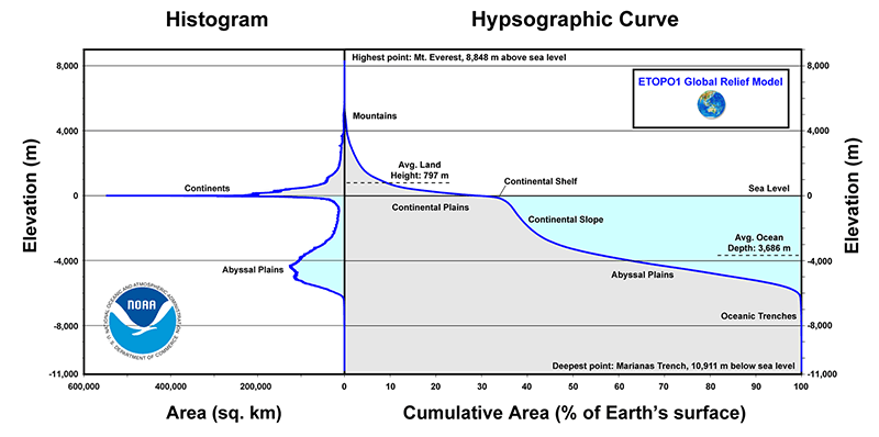
On the continents, mountain belts are the most dramatic features. They range in elevation from Mount Everest, 8848 m (29,030 ft), in the Himalaya Mountains to older, deeply eroded ranges that are now barely above sea level. Granitic and metamorphic rocks are generally exposed in the cores of mountain ranges. The overlying rocks that cover most of the Earth's surface are sedimentary, mainly of shallow marine origin, which may or may not have been deformed. The deformation is the result of compression and tension that causes folding and faulting, and may be accompanied by intrusion and metamorphism. Movements and collisions of tectonic plates are the principal cause of mountain building. Mountains generally are formed over several tens of millions of years. The rocks deformed in the process are generally marine sedimentary rocks formed along the margins of continents. See also: Deep-marine sediments; Marine sediments; Metamorphic rocks; Orogeny; Sedimentary rocks
Some topographic mountains are formed by volcanoes. The most striking are long chains of andesitic stratovolcanoes, such as the Aleutian and Andean chains, formed as a result of melting in the mantle induced by sinking tectonic plates. See also: Volcano
Much of the surface of the continents is covered by a thin veneer of sedimentary rocks. Where the underlying rocks of the plains and hills that make up most of the continents are exposed, the rocks and their structures are similar to those found in most mountain ranges. This leads to the theory that continents are formed by the deeply eroded remnants of earlier mountain ranges, and that today's continents have been assembled by accretion and by plate collisions.
The topographic features underlying the oceans are similarly diverse and reveal more evidence of a dynamic Earth. The continental shelf, an area covered by shallow water, generally less than 150 m (500 ft) deep, surrounds the continents at most places. Such areas are generally underlain by continental, granitic rocks, and are submerged parts of the continents. Continental slopes are the transition between the continental shelf and the ocean floors. Their tops are generally less than 150 m below sea level, and they slope down to about 4400 m (14,000 ft). They are narrow, steep features, with slopes generally between 2 and 6°, but some are up to 45°. They are generally underlain by thick accumulations of sedimentary rocks. See also: Seafloor imaging
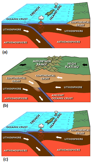
Submarine trenches and their associated volcanic island arcs are formed as a result of a tectonic plate of lithosphere sinking into the mantle beneath the edge of an overriding plate. The deepest place on Earth is in the Mariana Trench, 11,022 m (36,152 ft) below sea level.
The ocean floor is the most widespread surface feature of Earth. Beneath an average of 4.4 km (2.75 mi) of seawater are about 2.3 km (1.4 mi) of sedimentary rocks with some intercalated basalt, and below that is the oceanic crust, consisting of 4–6 km (2.5–3.7 mi) of basaltic rocks. Interrupting the ocean floor at many places are submarine mountains formed by basaltic volcanoes. Some of these volcanoes are very large and form oceanic islands such as the Hawaiian Islands. At other places, vertical movements of the ocean floor are revealed by sunken islands whose flat tops were formed by wave erosion (guyots) and coral atolls.
The ocean floor rises gradually to the mid-ocean ridges, a more or less continuous feature through all the oceans with some branches and offsets. The ridges range between 480 and 4800 km (300 to 3000 mi) wide and are much more rugged and irregular than the ocean floors. They rise about 3000 m (10,000 ft) above their base on average. Lines of parallel volcanoes, steep scarps, and a central valley mark the mid-ocean ridges. The central parts of the generally more or less symmetrical ridges are the most active volcanically and seismically. See also: Marine geology; Mid-Oceanic Ridge
The source of the heat energy that deforms the surface rocks is the crystallization of the liquid core and the decay of radioisotopes within the whole Earth. The energy released at the bottom of the mantle may be the cause of convection in the mantle, which in turn causes plate tectonics and so deforms the crust, but the actual processes are probably much more complex and are not yet clearly understood. See also: Radioisotope (geochemistry)
Plate tectonics
New oceanic lithosphere capped by basaltic crust is created at the mid-ocean ridges, and this newly formed plate moves away from the ridges (Fig. 4). The tectonic plates formed in this way may carry continents on them, and are the mechanism of continental drift. Paleomagnetic data from the continents indicate that the continents have moved relative to each other. The tectonic plates capped by basaltic crust plates are consumed at the trench–volcanic island arc areas. See also: Paleomagnetism; Subduction zones
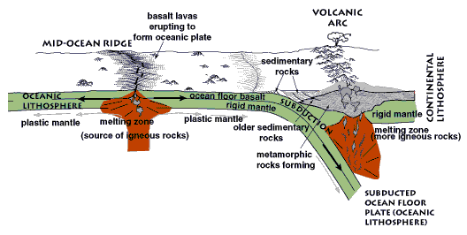
As well as the ridge and the trench, a third type of plate boundary occurs where two plates slide past each other at a transform fault. Moving plates may collide in several ways (Fig. 5). Such collisions account for the deformed rocks found in the crust. See also: Transform fault
The evidence for continental drift in the geological past includes matching of rock types, ages, fossils, climates, and structures (mountain ranges), as well as the paleomagnetic data. Evidence showing or suggesting present movements consists of shallow earthquakes along mid-ocean ridges and transform faults that offset them; deep earthquakes associated with deep-sea trench–volcanic island arc areas; direct measurement of movement; volcanic activity at mid-ocean ridges; and volcanic activity at trench–island arc areas. See also: Geodesy
Atmosphere
Earth's temperature and gravitation are such that an atmosphere is present. The major constituents are nitrogen and oxygen. The atmosphere, especially oxygen, and the presence of water, both at the surface and in the atmosphere, make life possible. Precipitation, mainly rain, results in running water such as streams and rivers on the continents. Running water is the main cause of erosion of the continents, and most of the landscapes have been eroded by water, although some are eroded by wind or ice (glaciers). See also: Atmosphere; Erosion; Glaciology; Gravity; Nitrogen; Oxygen; Water
The atmosphere shields Earth from most meteorites. Meteors are caused by frictional heat when such high-velocity objects move through the atmosphere. A few of these objects pass through the atmosphere and strike Earth, causing craters. Other bodies, such as the Moon, are not protected by an atmosphere and so are struck more frequently by meteorites. The craters formed on the Moon are preserved, because without an atmosphere almost no erosion occurs. See also: Meteorite
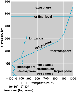
A thin ozone layer in the atmosphere also shields the Earth from lethal ultraviolet radiation from the Sun. The structure and composition of the atmosphere is shown in Fig. 6. See also: Ozone
Age
Earth, along with the rest of the solar system, is believed to have formed about 4.55 billion years ago. This age is determined by dating radioactive isotopes in meteorites. Meteorites are believed to be fragments produced by collisions among small bodies formed by the same process that created the solar system. Theoretical studies of the Sun and other studies of radioactive isotopes also suggest a similar age. See also: Earth's age