Key Concepts
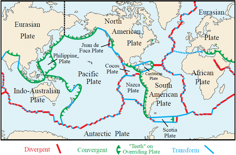
The theory explaining the movement across the Earth's surface of the rigid plates that make up the Earth's lithosphere. Numerous other geological phenomena such as lateral variations in surface heat flow, the physiography and geology of ocean basins, and various associations of igneous, metamorphic, and sedimentary rocks can also be logically related by plate tectonics theory (Fig. 1).

Theory and Evidence
The theory is based on a simple model of the Earth in which a rigid outer shell 30–90 mi (50–150 km) thick, the lithosphere, consisting of both oceanic and continental crust as well as the upper mantle, is considered to lie above a hotter, weaker semiplastic asthenosphere. The asthenosphere, or low-velocity zone, extends from the base of the lithosphere to a depth of about 400 mi (700 km). The brittle lithosphere is broken into a mosaic of internally rigid plates that move horizontally across the Earth's surface relative to one another. Only a small number of major lithospheric plates exist, which grind and scrape against each other as they move independently like rafts of ice on water. Most dynamic activity such as seismicity, deformation, and the generation of magma occurs only along plate boundaries, and it is on the basis of the global distribution of such tectonic phenomena that plates are delineated. See also: Asthenosphere; Earth's interior; Lithosphere
The plate tectonics model for the Earth is consistent with the occurrence of seafloor spreading and continental drift. Convincing evidence exists that both these processes have been occurring for at least the last 600 million years ago (MYA). This evidence includes the magnetic anomaly patterns of the seafloor, the paucity and youthful age of marine sediment in the ocean basins, the topographic features of the seafloor, and the indications of shifts in the position of continental blocks which can be inferred from paleomagnetic data on paleopole positions, paleontological and paleoclimatological observations, the match-up of continental margin and geological provinces across present-day oceans, and the structural style and rock types found in ancient mountain belts. See also: Continental drift; Continental margin
Plate motion and boundaries
Geological observations, geophysical data, and theoretical considerations support the existence of fundamentally distinct types of plate boundaries, named and classified on the basis of whether immediately adjacent plates move apart from one another (divergent plate margins), toward one another (convergent plate margins), or slip past one another in a direction parallel to their common boundary (transform plate margins). Figure 1 shows the major plates of the lithosphere, the major plate margins, and the type of motion between plates. Plate margins are easily recognized because they coincide with zones of seismic and volcanic activity; little or no tectonic activity occurs away from plate margins. The boundaries of plates can, but need not, coincide with the contact between continental and oceanic crust. The nature of the crustal material capping a plate at its boundary may control the specific processes occurring there, particularly along convergent plate margins, but in general plate tectonics theory considers the continental crustal blocks as passive passengers riding on the upper surface of fragmenting, diverging, and colliding plates.
The velocity at which plates move varies from plate to plate and within portions of the same plate, ranging between 2 and 20 cm per year. This rate is inferred from estimates for variations in the age of the seafloor as a function of distance from mid-oceanic ridge crests. Ocean-floor ages can be directly measured by using paleontological data or radiometric age-dating methods from borehole material, or can be inferred by identifying and correlating the magnetic anomaly belt with the paleomagnetic timescale.
Divergent plate margins
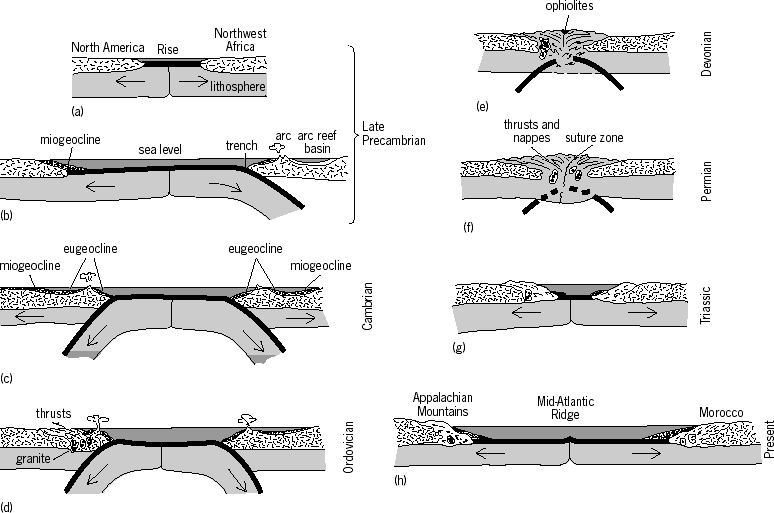
As the plates move apart from the axis of the mid-oceanic ridge system, the new volcanic material welling up into the void forms a ribbon of new material, which gradually splits down its center as the boundary of plate separation continues to develop (Fig. 2). Each of the separating plates thus accretes one-half a ribbon of new lithosphere, and in this way new lithosphere and hence new surface area are added. The process is considered to be continuous, and the boundary at which separation is taking place always maintains itself in the center of the new material. See also: Mid-Oceanic Ridge

The accretion at any spreading boundary is usually bilaterally symmetric. The morphology of the ridges is also quite symmetric and systematic. The new material that wells up at the ridge axis is hot and therefore expanded and less dense than the surrounding older material. Consequently, the new material is topographically highest. As new material divides and moves away from the ridge axis, it cools, contracts, becomes denser, and subsides. The densification is caused by the combined effect of pure thermal contraction and thermally driven phase changes. Subsidence is fastest for newly generated oceanic crust and gradually decreases exponentially with time. This observation explains the fact that in cross section the shape of the slope of the ridges is steepest at the ridge axis and gradually decreases down the flanks beneath the abyssal sediments and to the bounding continents. Since all known oceanic lithosphere has been generated by the spreading at a ridge axis, all oceanic lithosphere is part of the mid-oceanic ridge system. Because of the systematic way in which the morphology of the ridges is formed, most oceanic crust follows the same time-dependent subsidence curve within an error range of about 100 m. This means that the same age-versus-depth curve fits nearly all parts of the mid-oceanic ridge system. The ridge axis is found at a depth of 2.75 km ± 100 m, and oceanic lithosphere that is 30 MYA old is found at a depth of 2.72 ± 300 ft (4.37 km ±100 m). There are exceptional areas such as Iceland where the ridge axis is above sea level.
Convergent (destructive) plate margins
Because the Earth is neither expanding nor contracting, the increase in lithosphere created along divergent boundaries must be compensated for by the destruction of lithosphere elsewhere. The rates of global lithosphere construction and destruction must be equal, or the radius of the Earth would change. Compensatory destruction or removal of lithosphere occurs along convergent plate margins (subduction zones) and is accomplished by plate subduction and continental collision. See also: Subduction zones
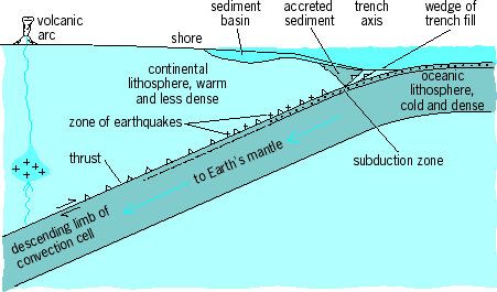
Along subduction zones, one plate plunges beneath another (Fig. 3). The downgoing slab is usually oceanic because the relatively buoyant continental lithosphere cannot be subducted beneath the relatively denser oceanic lithosphere. The upper or overriding plate may be continental or island arc lithosphere, and occasionally oceanic plateaus as in the case of Oregon and Alaska.

The dip of the downgoing underthrust slabs varies but averages 45°. Earthquake foci along individual subduction zones indicate the plate underthrust angle, often referred to as the Benioff plane or Wadati-Benioff zone. This plane dips away from oceanic trenches toward adjacent volcanic arcs and continents, and marks the surface of slippage between the overriding and descending lithospheric plates. Successive belts of shallow (less than 40 mi or 70 km), intermediate (40–200 mi or 70–300 km), and deep-focus (200–400 mi or 300–700 km) earthquakes are associated with subduction zones. Subduction zones are also associated with active volcanism and the development of deep-ocean trenches. These features encircle the Pacific Ocean basin.
A line of andesitic volcanoes usually occurs on the upper plate, forming a chain that is parallel to the trench. The volcanism occurs at that point above the subduction zone where the upper surface of the downgoing lithosphere has reached a vertical depth of approximately 75 mi (120 km). The volcanic materials arise from partial melting of the downgoing slab. The volcanoes of the Andes chain of South America and island arcs in the Pacific such as Izu-Bonin and the Mariana have formed in this manner.
Convergent plate margins that develop island arc systems adjacent to trench systems are geologically complex. The region between a volcanic island arc and the trench consists of volcanic rock and sediments. Slumping and turbidity currents transport sediment into the trench axis. The trench sediment may be transferred from the downgoing plate to the continent or island arc. Conversely, a convergent margin without a large sediment supply may be eroded during subduction. See also: Depositional systems and environments; Turbidity current
Because of density consideration, subduction requires at least one of the two converging plates to be oceanic. If both converging plates consist of continental lithosphere, continental collision occurs, but not subduction. Continental collision results in compensatory reduction in lithospheric width by folding and compressing the lithosphere into narrower, linear mobile belts. In such collisions, sediments deposited along the continental margins and within the closing ocean basins are compressed into a series of tight folds and thrusts. Fragments of oceanic crust may be thrust up onto adjacent continental rocks (obduction) as ophiolite successions. A classic example of a continental collision belt is the Himalayan belt, produced during the Cenozoic Era by the convergence of the Indian continent with Eurasia. See also: Ophiolite; Orogeny
Like plate divergence, plate convergence produces a distinctive suite of igneous rock types. Subduction zones are marked by the belts of predominantly andesitic volcanoes either in island arcs located landward of the trench system (Japan and the Philippines) or along the rim of overriding continental blocks (the Andes belt). These andesitic volcanic terranes are commonly associated intimately with plutonic igneous rocks, mainly granodiorites. The origin of andesitic magmas, and the predominance of granodiorite plutons within continental blocks to the exclusion of most other igneous rock varieties, was perplexing until the development of plate tectonics theory. Now both seem to be directly related to the generation of parent magmas by the frictional melting of ocean-floor basalt and overlying sediment cover along subduction zones. Partial melting of the lower crust and upper mantle also occurs. See also: Basalt; Granodiorite; Igneous rocks; Magma; Volcano
Plate subduction and continental collision can also explain the origin of two other puzzling rock sequences commonly found within mountain belts: mélange and blueschist terranes. Mélange, a heterogeneous assemblage of intensely sheared, poorly sorted, angular blocks set in a fine-grained matrix, is probably generated at shallow depths along subduction zones as the oceanic crust and overlying sediment cover of the descending plate are scraped and crushed against the overriding plate. Blueschist terranes (their dark blue color is imparted by the presence of various low-temperature–high-pressure metamorphic minerals such as glaucophane, lawsonite, and jadeite) occur in belts within mountain chains, parallel with but external to (toward the ocean) the more conventional paired metamorphic facies of the greenschist terrane. The peculiar physical conditions required by the blueschist facies, great burial depth (in excess of 10 mi or 16 km) but moderate temperature (390–800°F or 200–450°C), should be generated along subduction zones when the descending lithospheric plate is underthrust at a greater rate than the local geothermal gradient can heat it. See also: Blueschist
Transform plate margins
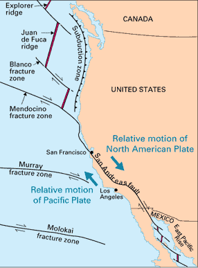
Transform faults are always strike-slip faults. They occur where the relative motion between the two plates is parallel to the boundary that separates the plates (Fig. 4). They may join a ridge to a ridge, a ridge to a trench, or a trench to a trench. Ridge-trench transforms will always change length with time. A trench-trench transform may lengthen, shrink, or remain constant, depending on which of the plates that form the subduction system is the downgoing plate. A transform that joins two ridge axes will not change in length with time. See also: Fault and fault structures; Transform fault

First, consider ridge-ridge transforms. Earthquake epicenter data show that earthquakes occur only along the ridge axes and the connecting transform. Studies of earthquakes that occur at a ridge-ridge transform fault show that the first motion was strike-slip parallel to the direction of the transform and opposite to the sense of offset of the ridge axis. If the ridge axes are offset left-laterally, the relative motion across the transform that joins the ridges will be right-lateral as the plates separate. The motion of the fault takes place spasmodically. Deformation occurs on either side of the fault until the elastic limit is reached and the rupture occurs, causing an earthquake. See also: Earthquake
A very narrow and deep rift valley is also associated with the transform. However, because of time-dependent cooling, the oceanic lithosphere contracts horizontally. This contraction causes cracking of the lithospheric plate and widening and splaying of the rift associated with the fracture zone. Young fracture zones are characterized by an escarpment and a deep fissure along their length. The magnitude of the vertical offset decreases with age, and the fissure tends to widen. Down the lower flanks of the ridges, turbidities from the abyssal plains often finger into the fracture zone. The fracture zones form long curvilinear features throughout the oceans and are mappable because of morphology alone. See also: Rift valley
The numerous strike-slip faults, which offset segments of the mid-oceanic ridge system, are classical examples of transform plate boundaries. The San Andreas system of California, which offsets portions of the East Pacific Rise, is probably the best-known example (Fig. 4). Transform faults show apparent lateral displacements of many tens or even hundreds of kilometers. Occasionally extension, and consequent igneous activity, may occur at a transform fault.
Triple junctions
The point where the boundaries between three pairs of plates join is known as a triple junction. Because the Earth's lithosphere shell is segmented into a mosaic, the boundary between any two plates must end in a triple junction. Quadruple junctions are theoretically possible, but except under very unusual circumstances they degenerate immediately into two triple junctions. Figure 1 shows a number of triple junctions that vary as to the types of boundaries that meet and as to the geometry.
When three bodies are moving with respect to each other across a spherical surface, if the relative motion of each of two pairs of the plates is known, the relative motion of the third pair may be determined. In the case of a spherical surface, the relative motion between two plates may be represented by a vector through the pole of instantaneous relative motion, with the length of the vector proportional to the rate of rotation. The relative motion of three plates or bodies on a sphere may be represented by three such vectors. Each vector gives the instantaneous relative motion of two of the three plates. Thus, three such vectors describe completely the relative motion of the three plates and must add to zero.
The orientation of the boundary between these plates will determine the type of interaction at the boundary (that is, spreading, subduction, or transform). There are a number of possible triple junctions. The Cocos, Pacific, and Nazca plates join at a ridge-ridge-ridge triple junction (Fig. 1). This is an example of a stable triple junction, that is, the triple junction moves in a constant direction and at a constant speed with respect to each of the plates. Other triple junctions are unstable or transitional, such as a ridge-ridge-transform triple junction which will change immediately to a transform-ridge-transform triple junction. The most geologically important triple junctions are those that migrate along a boundary. Consequently, the boundary along which the triple junction moves will experience a change in the direction of relative motion. If the change in relative motion is radical, there may be an accompanying change in tectonic style. This type of plate interaction occurred at the western boundary of the North American Plate during the Cenozoic, and has resulted in a time transgressive change, from south to north, from subduction to strike slip. This is reflected in the geologic record as a change from compressive tectonics with thrusting, folding, and Andean or island arc volcanism to strike slip, as occurs along the San Andreas Fault.
Hot spots and mantle plumes
The existence of convective plumes originating in the deep mantle from below the level of the asthenosphere and rising to the bottom of the lithosphere has been proposed. About 14 major convective plumes are believed to exist today. These plumes are believed to be nearly stationary with respect to each other, and hence they may be used as reference points with respect to which all the plates are moving. Mantle plumes, rather than convection currents, may also be the driving mechanism for plate motion. The latter two hypotheses are not necessary conditions for the validity of the first. In other words, there may be mantle plumes that rise to the bottom of the lithosphere, but they may not be stationary with respect to each other and may not furnish the plate driving mechanism. The major clue to the existence of hot spots is the lines of intraplate volcanoes that are left as a trace of the passage.
As a plate passes over a hot spot, the hot spot burns its way through the plate. This releases volatile and eruptive magma on the plate surface. A classic example of the “volcanic” consequences of passage of a plate over a hot spot is the Hawaiian-Emperor Seamount chain. Hawaii and the islands immediate to it are volcanically active at present. The rest of the islands and seamounts of the Hawaiian and Emperor chains are inactive, but all are of volcanic origin. The islands and seamounts are found to be sequentially older west-northwestward along the Hawaiian chains and are progressively older north-northwestward along the Emperor Seamount chain. As an explanation, it has been hypothesized that the Pacific Plate moved first north-northwesterly and then west-northwesterly over a single hot spot. Other seamount chains in the Pacific, such as the Line Islands, the Tuamotu Archipelago, and the Austral Seamount chain, are presumed to be of similar origin. See also: Hot spots (geology); Oceanic islands
In the Atlantic, features that are regarded as major hot-spot traces are Iceland and the Iceland Faroes Ridge, the New England Seamount chain, the Columbia Seamount chain, the Rio Grande Rise, and Walvis Ridge; and in the Indian Ocean, the Ninety-East Ridge is an analogous feature. The age progression along each of these features has been estimated; the theory that these hot spots have remained fixed in position relative to each other has been tested. The results indicate that some relative motion may occur, but it appears to be an order of magnitude less than the generally observed rate of interplate motion.
The hot spot hypothesis is a significant complement to plate tectonics. There is little doubt that hot spots or plumes of some type do occur. Intraplate volcanism often seems to be a manifestation of their existence. If, in addition, the hot spots prove to be essentially stable with respect to the rotational axis, they may be useful as a reference frame. They could serve as a latitudinal constraint in addition to paleomagnetic data. They could also be very useful in finding the relative motion between plates that have been separated by subduction zones or transform faults (that is, Pacific–North America relative motion).


