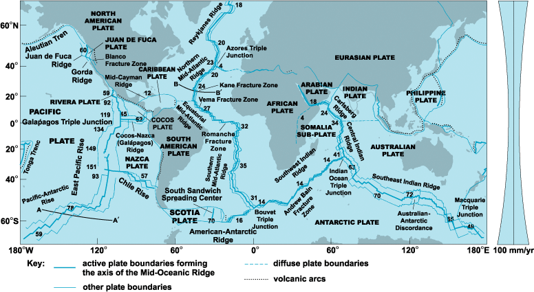
A largely interconnected system of broad submarine rises totaling at least 60,000–80,000 km (37,000–50,000 mi) long, the precise length depending on what is included and how it is measured. Thus the Mid-Oceanic Ridge is the longest mountain range system on the planet. The origin of the Mid-Oceanic Ridge is intimately connected with plate tectonics. Wherever plates move apart sufficiently far and fast for oceanic crust to form in the void between them, a branch of the Mid-Oceanic Ridge will be created (Fig. 1). The plate boundary of the Mid-Oceanic Ridge comprises an alternation of spreading centers (or axes or accreting plate boundaries) interrupted or offset by a range of different discontinuities, the most prominent of which are transform faults. As the plates move apart, new oceanic crust is formed along the spreading axes, and the ideal transform fault zones are lines along which plates slip past each other and where oceanic crust is neither created nor destroyed. Bruce Heezen, who pioneered studies of the Mid-Oceanic Ridge, once referred to this feature as a “wound that never heals.”

The term Mid-Oceanic Ridge is somewhat a misnomer, having been applied before its tectonic significance (a system of spreading axes connected by transform faults) was appreciated. The ridge generally remains in the middle of an ocean basin only if that basin has formed between two continents rifted apart, and the average spreading rates on each flank have been the same. Some spreading axes are located near the edges of ocean basins and behind island arcs. See also: Plate tectonics; Transform fault
Separation of plates causes the hot upper mantle to rise along the spreading axes of the Mid-Oceanic Ridge; partial melting of this rising mantle generates magmas of basaltic composition that segregate from the mantle and rise in a narrow zone at the axis of the Mid-Oceanic Ridge to form the oceanic crust. The partially molten mantle “freezes” to the sides and bottoms of the diverging plates to form the mantle lithosphere that, together with the overlying “rind” of oceanic crust, comprises the lithospheric plate. At the axis of the Mid-Oceanic Ridge the underlying column of crust and mantle is hot and thermally expanded; this thermal expansion explains why the Mid-Oceanic Ridge is a ridge. With time, a column of crust plus mantle lithosphere cools and shrinks as it moves away from the ridge axis as part of the plate. The gentle regional slopes of the Mid-Oceanic Ridge (typically from 3 to 50 parts per thousand near the axis, and decreasing smoothly toward the flanks) therefore represent the combined effects of sea-floor spreading (divergent plate motion) and thermal contraction. The height and shape of the average Mid-Oceanic Ridge profile in meters of depth are approximated by the formula D = 2900 + 350 , where T is the age of the crust in millions of years. For example, the depth of 4-million-year-old crust is 2900 + 350 , or 3600 m (12,000 ft). This formula predicts that the Mid-Oceanic Ridge will be bilaterally symmetric as long as spreading is symmetric (that is, crust is accreted at the same rate to both plates). See also: Earth crust; Lithosphere
Width and related effects
The height and thermal contraction rate of the ridge crest are relatively independent of the rate of sea-floor spreading; thus, the width and regional slopes of the Mid-Oceanic Ridge depend primarily on the rate of plate separation (spreading rate). Where the plates are separating at 2 cm (0.8 in.) per year (for example, along the northern Mid-Atlantic Ridge; Fig. 1), the Mid-Oceanic Ridge has five times the regional slope but only one-fifth the width of a part of the ridge forming where the plates are separating at 10 cm (4 in.) per year (for example, the northern East Pacific Rise; Fig. 1). One consequence of the relation between the width and plate separation rate of the Mid-Oceanic Ridge is that more ocean water is displaced, thereby raising sea level, during times of globally faster plate motion. Observed long-term changes in global (eustatic) sea level probably reflect the combined effect of changing length of the total Mid-Oceanic Ridge and changing average rates of plate motion. About 80 million years ago, in the Late Cretaceous, sea levels were about 300 m (1000 ft) higher than today, primarily because of more rapid plate motion and a wider Mid-Oceanic Ridge.
The modern Mid-Oceanic Ridge is typically 1000–4000 km (600–2500 mi) wide, depending on the rate of plate separation and other factors. Actually, the ridge as a feature of thermal expansion has no sharp outer edge; the plate continues to cool and contract gradually and at ever-decreasing rates. However, the outer edge may be defined functionally as that line or zone beyond which the sea floor, deepening from the axis of the Mid-Oceanic Ridge, ceases to deepen further. Several processes can affect the location of the ridge's outer edge. Where postulated plumes of hot mantle material rise under the plates away from the axis of the Mid-Oceanic Ridge, the crust and mantle lithosphere become reelevated by as much as 1000–2000 m (3300–6600 ft). Whether formed by such a plume or not, an example of such a midplate swell is the Bermuda Rise.
Sedimentation is another process that helps give the Mid-Oceanic Ridge an outer edge. If hemipelagic sedimentation (sediment dropping down on the sea floor from the surface waters) were constant over a given part of the Mid-Oceanic Ridge, sediment thickness would increase linearly with crustal age away from the ridge axis. Although the sediment load depresses the lithospheric plate by a certain amount, the net effect of sedimentation is to make the ocean less deep. The outer edge of the Mid-Oceanic Ridge would be that line or zone where thermal subsidence of the lithospheric plate equals the shoaling effect of sedimentation. With greater distance from the Mid-Oceanic Ridge, the effect of constant sedimentation would exceed that of thermal contraction and the sea floor would rise. In some ocean basins the more dramatic effects of turbidity (suspension) flows have overwhelmed hemipelagic sedimentation by depositing large numbers of turbidites (vertically and horizontally graded sheets of sand, silt, and clay) to form the abyssal plains between the continental margins and the Mid-Oceanic Ridge. As the abyssal plains were built up in this fashion, they simultaneously extended seaward, inundating the lower flanks of the Mid-Oceanic Ridge and displacing its outer edge. Turbidite deposition was greatly accelerated as a result of expanded Plio-Pleistocene glaciation and resultant low sea levels; and so the Mid-Oceanic Ridge, particularly in the North Atlantic, is somewhat narrower than it was prior to this glacial expansion. See also: Basin; Continental margin; Isostasy; Marine sediments; Turbidite; Turbidity current
Hot spots
Although the Mid-Oceanic Ridge exhibits little systematic depth variation along much of its length, there are several bulges (swells) of shallower sea floor. The shallow part of the Mid-Atlantic Ridge centered at Iceland is the most prominent example. Such bulges represent 500–3500-m (1600–11,000-ft) shallower-than-normal sea floor along sections of the Mid-Oceanic Ridge that are 500–3000 km (300–1900 mi) long. The features are attributed by some scientists to mantle hot spots, upwelling plumes with warmer-than-average mantle temperature. It may be that off-axis swells like the Bermuda Rise ultimately have the same origin as on-axis ones like the Iceland or Azores swells. For reasons not well understood, the sea-floor bulges are more prominent along parts of the Mid-Oceanic Ridge where the rate of plate separation (spreading rate) is slower; for example, along the northern Mid-Atlantic Ridge and the Southwest Indian Ridge. See also: Hot spots (geology)
Local topography
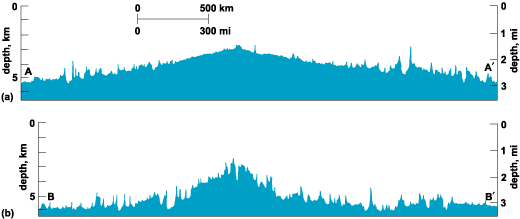
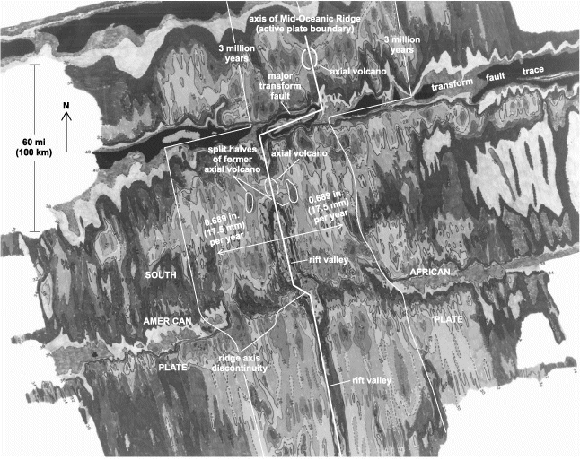
The average (or regional) depth and shape of the Mid-Oceanic Ridge is modulated by more local topographic relief, some of which equals or exceeds the regional ridge in amplitude (just as the local relief represented by Pikes Peak exceeds the regional topographic high of the Rocky Mountains) [Figs. 2 and 3]. Whereas the regional elevation of the Mid-Oceanic Ridge is determined by the thermal structure of the upper mantle and in part by average crustal thickness, the local relief is largely the result of tectonic deformation (principally normal faulting) and volcanism. The most prominent local topographic feature is the axis itself, which for opening rates less than 3.4 cm (1.3 in.) per year is a 20–40-km-wide (12–25 mi) rift valley 1000–2800 m (3300–9200 ft) deeper than the flanking rift mountains. This rift valley was first noticed on echo-sounding lines across the Mid-Atlantic Ridge by Marie Tharp (Lamont-Doherty Earth Observatory) in 1953. At opening rates above 9 cm (3.5 in.) per year, there is a topographic high at the axis, and at intermediate rates a rift valley tends to occur only at triple plate junctions and intersections with transform faults. Where a rift valley is present on the axis of the Mid-Oceanic Ridge, the flanks tend to exhibit rough (±500 m or 1600 ft) topography, which is thought to originate by temporal changes in the level of the rift valley floor. See also: Fault and fault structures; Rift valley


Aside from local failure of steep volcanic or tectonic escarpments—generally only on young crust near the axis of the Mid-Oceanic Ridge—and widely scattered off-axis (midplate) volcanism, the oceanic crust and its surface topography are passively carried away, slowly disappearing below the ever-thickening sediment cover. Except for the effects of sedimentation, the local topography on the flanks of the Mid-Oceanic Ridge is similar to that on the crest. Aside from the small area of oceanic crust exposed on Iceland, the topography of the Mid-Oceanic Ridge is essentially protected from significant erosion. Parts of the ridge may be exposed to deep currents up to about 1 knot (50 cm/s), but such currents suffice only to erode and redeposit sea-floor sediments, not the basaltic topography that may be exposed to the currents. See also: Volcanology
When local topographic effects are included, the maximum relief along the Mid-Oceanic Ridge axis is about 10,000 m (33,000 ft). The highest points are central volcanoes constructed on the hot-spot bulges (although generally some tens of kilometers to a hundred kilometers from the active plate boundary). Away from hot-spot bulges, the highest peaks of the Mid-Oceanic Ridge rarely breach the sea surface. More dramatic topographic relief forms near the intersections of transform faults and spreading axes (spreading centers). The rift valley deepens as it approaches its termination at a transform fault, forming a nodal basin. Transform faults are generally marked by prominent valleys, which serve as permanent traces of relative plate motion; these transverse valleys crosscutting the Mid-Oceanic Ridge are continuously generated at the site of the nodal basins. The greater the offset across a transform fault (offset being measured by the age of the old crust next to the nodal basin), the deeper the nodal basin and associated fracture zone valley.
Axial phenomena
The detailed shape of the Mid-Oceanic Ridge is not just a simple alternation of transform faults and spreading centers. Interspersed between transform faults are lesser irregularities ranging from ridge axis discontinuities (significant offset of the axis but without transverse fault development) down to minor departures from linearity. The smaller the irregularity, the more ephemeral the feature. When the offset is small, the tips of the offset spreading center may propagate past each other, forming so-called overlapping spreading centers. This is an unstable configuration and results in deformation of the crust between the overlappers. When one center continues to propagate at the expense of the offset spreading center, the result is a propagating rift. Such rifts tend to propagate away from the regional topographic bulges. Smaller-scale irregularities of the ridge axis are probably related to local volcanic centers developed several tens of kilometers to a hundred kilometers apart along the axis.
The axis of the Mid-Oceanic Ridge—that is, the active plate boundary between two separating plates—is a narrow zone only a few kilometers wide, characterized by frequent earthquakes, intermittent volcanism, and scattered clusters of hydrothermal vents where seawater, percolating downward and heated by proximity to hot rock, is expelled back into the ocean at temperatures as high as 350°C (660°F). Surrounding such vents are deposits of hydrothermal minerals rich in metals, as well as exotic animal communities including, in some vent fields, giant tubeworms and clams. Sulfate-reducing bacteria, rather than photosynthesizing plants, are the base of the food chain at the vents. Life on Earth may have originated in hydrothermal vent environments similar to those presently found along the axis of the Mid-Oceanic Ridge. See also: Hydrothermal vent; Volcano
Extinction
If a particular section of the Mid-Oceanic Ridge becomes inactive—through cessation of sea-floor spreading—it is referred to as an extinct (or abandoned) spreading axis or center. This may happen on the scale of an entire plate boundary, such as 36 million years ago, when spreading ceased along the Mid-Labrador Sea Ridge between Greenland and North America; as a result, the entire Greenland plate became part of the North American plate. More commonly, only short sections of accreting plate boundary are abandoned as a section of boundary jumps to a new location inside preexisting crust. Propagating rifts create a special category of extinct spreading center known as failed rifts. As rifts propagate continuously, the extinct spreading center is abandoned continuously and therefore varies in age along its length.
After a section of Mid-Oceanic Ridge becomes extinct, its regional topographic high gradually decays as a result of cooling and thermal contraction. For example, the axis of a ridge that died 36 million years ago is no longer 2900 m (9500 ft) deep, but has subsided to a depth of 2900 + 350, or 5000 m (16,400 ft), and thus is barely recognizable as a ridge. However, the shorter-wavelength topography does not decay, and the site of an extinct ridge will generally still be recognizable by its median rift valley, symmetric magnetic anomaly pattern, and other features.
Deep structure
The properties of the crust and upper mantle below the Mid-Oceanic Ridge have been inferred mostly from seismic waves generated by earthquakes and by artificial sources such as explosions and air guns. By contrast, the deepest oceanic borehole penetration (on the flanks of the Galápagos Ridge) is so far only about 1850 m (6100 ft); on Iceland the deepest penetration is 2820 m (9250 ft), 4300 m (14,000 ft) below the original uneroded land surface. None of these drill holes have penetrated to the Moho (seismic M-Discontinuity), the boundary between the crust and upper mantle. However, it is believed that rock assemblages known as ophiolites, exposed in ancient mountain belts, represent remnants of former oceanic crust and uppermost mantle that are tectonically separated from the main down-going slab and thrust into the upper continental crust. At least in terms of physical properties such as seismic-wave velocity, the ophiolites resemble the modern oceanic crust as determined by geophysical measurements. See also: Moho (Mohorovičić discontinuity); Ophiolite
Although magma (molten rock) erupts occasionally onto the sea floor at the axis of the Mid-Oceanic Ridge, seismic methods have failed to detect a continuous crustal magma chamber, at least below slow-spreading ridges. However, this hot mantle is partially molten at depths of between about 10 and 50 km (6 and 30 mi) below the axis of the Mid-Oceanic Ridge. Seismic tomography indicates that the anomalously warm, rising mantle below the Mid-Oceanic Ridge probably extends to depths of several hundred kilometers. See also: Magma; Marine geology


